


EXTON, PA, USA and MUMBAI, India, Sep 28, 2022 – Bentley Systems, Incorporated (Nasdaq: BSY), the infrastructure engineering software company, and Genesys International, a pioneer in advanced mapping and geospatial content services, today announced that Genesys’ 3D City Digital Twin Solution for Urban India – the first city digital twin project launched by any Indian company – will be powered by OpenCities 365, Bentley’s infrastructure digital twin solution for cities and campuses. This massive mapping and surveying project has begun and will capture most of urban India.
Genesys previously partnered with Bentley to successfully pilot an earlier digital twin solution that enabled the smart inventory management of telecom infrastructure using Bentley’s OpenTower iQ software. The robust solution provided operators with accurate and up-to-date information on planning and installing 5G towers, which saved time as well as the cost of conducting labor-intensive tower inspections.
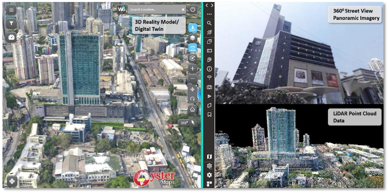
“The Genesys 3D City Digital Twin Solution for Urban India, powered by Bentley’s OpenCities 365, will enable us to create and curate city-scale digital twins that empower government and private entities across India to improve their execution, efficiency, and strategizing capabilities using the 3D data,” said Sajid Malik, chairman and managing director at Genesys International. “This extraordinary solution enables capturing the as-built assets from the field and bringing them to the office in a reality model. We are impressed with the technical capabilities of Bentley’s digital cities portfolio and see it as a key differentiator that will help proactively improve our existing digital capabilities through a continued partnership between Bentley and Genesys International.”

Once a 3D digital twin for each of the cities is ready, engineering and application data layers can be added based on an end-user’s requirements. These 3D city digital twins will enable local governments to improve public services, including urban governance, disaster management, emergency response, and tourism. Additionally, it will help governments deliver more resilient and sustainable environments for their citizens through enhanced urban development, optimized road, rail, utility, and water network upgrades, location-based services, and other smart city initiatives. On the private corporate front, processes followed in verticals such as telecommunications and broadband infrastructure, city gas distribution, e-commerce, construction, autonomous navigation, renewable energy and various other verticals will be served and modernized by these 3D digital twins. The openness of Bentley applications provides Genesys further benefit because the software can connect with other asset management systems, such as third-party geospatial information systems, to capture and read that data.
Kaushik Chakraborty, Bentley’s vice president, regional executive, Asia Pacific, said, “We are extremely happy to contribute to this massive mapping project of national importance with our technology and services. The 3D cities digital twin project will enable our public agencies, service providers, and citizens to deliver or avail services, plan and execute projects, make informed decisions, and improve their quality of life.”
Chakraborty added, “The initiative will also drive the adoption of digital technology in the infrastructure segment. The output from this project will serve as the foundation for initiatives that we can launch to sustain the economy and environment.”
About Bentley Systems
Bentley Systems (Nasdaq: BSY) is the infrastructure engineering software company. We provide innovative software to advance the world’s infrastructure – sustaining both the global economy and environment. Our industry-leading software solutions are used by professionals, and organizations of every size, for the design, construction, and operations of roads and bridges, rail and transit, water and wastewater, public works and utilities, buildings and campuses, mining, and industrial facilities. Our offerings include MicroStation-based applications for modeling and simulation, ProjectWise for project delivery, AssetWise for asset and network performance, Seequent’s leading geoprofessional software portfolio, and the iTwin platform for infrastructure digital twins. Bentley Systems employs more than 4,500 colleagues and generates annual revenues of approximately $1 billion in 186 countries. For more information, visit www.bentley.com.
About Genesys International
Genesys International Corporation Ltd. is an advanced mapping and geospatial content company. With a team of 2000+ professionals and three decades of rich geospatial experience, Genesys works with leading Big Tech, Utilities, Infrastructure, State and Local Governments including the United Nations.
Its Genesys Constellation is one of the most advanced sensor networks built for India aiding in the process of capturing and creating the Digital Twin of entire Urban India at high speeds and accuracy. For more information, visit www.igenesys.com


