

MicroStation Improves Production Efficiency by 50%, Achieving Unprecedented Realistic Simulations
Building an Ecosystem of 3D City Models
Led by Japan’s Ministry of Land, Infrastructure, Transport, and Tourism (MLIT), Project PLATEAU is a 3D city model and digital twin initiative to build an open digital ecosystem of urban models for 500 Japanese cities by 2027. As Japan’s largest-scale city modeling scheme, the project aims to integrate digital city data in an open platform, allowing freely available access to city information. This information will be used for smart city management, urban planning, and various use cases, ranging from disaster prevention and preparedness to environmental protection, transportation, and sustainable development. Project PLATEAU will unlock the value of 3D city modeling and visualization by reproducing and simulating urban space in an interactive digital environment, creating new solutions for cities across Japan.
Providing turnkey geospatial solutions through data acquisition, processing, and analytics, Kokusai Kogyo, a leading geospatial-centric services and engineering consulting company in Japan and globally, conducted 3D modeling for several of the selected cities, including Numazu, a tourist town providing beautiful views of the Pacific Ocean and Mount Fuji. They created a high-fidelity 3D city model of Numazu for an autonomously driving electric bus. Kokusai Kogyo incorporated four different 3D city geometries within the model, comparing it with the visual positioning system attached to the bus that facilitated autonomous driving. “By comparing the information acquired through the camera attached to the bus with the information of the 3D city model, it estimates the position of the bus itself, including direction, and performs automatic driving,” said Tatsuya Muraki, engineer in charge at Kokusai Kogyo’s 3D city model promotion group in the geospatial technology department.
Processing Complex Voluminous Data
During 2020, the first year of the project, Kokusai Kogyo developed detailed 3D models for 15 cities, initially with levels of detail (LOD) at LOD 1, representing building shapes without roof structures. Later, they further developed the priority policy zones in each city with LOD 2. In 2021, while they were creating the Numazu city model, Kokusai Kogyo wanted to achieve a higher level of detailed 3D modeling, LOD 3, by incorporating intricate spaces, windows and doors, roadway traffic lights and signs, and vegetation. “Detailed 3D modeling makes it possible to develop a detailed and concrete understanding of the issues facing cities and achieve simulations that are closer to reality than previously possible,” said Muraki.
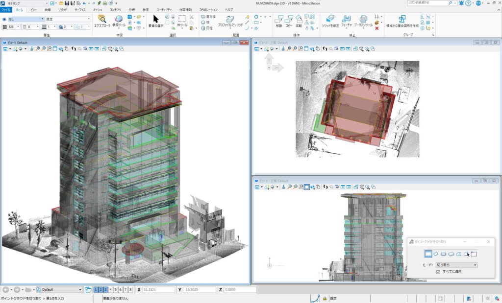
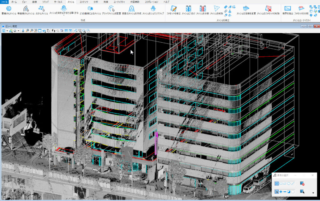
To create a model of that level of detail, however, Kokusai Kogyo needed to process voluminous and complex LiDAR point cloud and image data collected from their mobile mapping, car-based survey system. Previous CAD technology proved insufficient to meet Kokusai Kogyo’s desired outcome. “LOD 3 models are particularly complex, with wall surfaces in buildings that depict doors and windows. In addition, our project required other features, including trees and traffic infrastructure, such as traffic lights,” said Muraki. Kokusai Kogyo needed a technology solution with the capacity to model a large amount of complicated data to deliver LOD 3, digital models.

Bentley Applications Facilitate Precise 3D Modeling
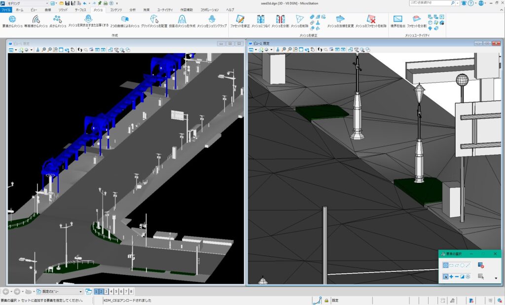
Kokusai Kogyo selected MicroStation to deliver the detailed Numazu 3D city model, aggregating the mobile mapping system data into LOD 3 models for the four different city geometries—buildings, roads, city furniture, and vegetation. “The geometry is created with MicroStation based on point cloud data surveyed from the mobile mapping system,” said Muraki. “MicroStation played an important role in constructing the most challenging data.” The software offered a range of functions for creating and editing complex 3D shapes. Using Bentley’s application, Kokusai Kogyo divided the building data, creating layers to model windows, doors, and roof surfaces. They did the same for the road models, building about 10 centimeters of steps between the roads and sidewalks, as well as for the city furniture models, creating very detailed data, such as the joints between the parts of the signs. For the vegetation models, they measured the size of each tree from the point cloud data to realistically replicate the tree geometry. “Of particular value to us was the capacity of MicroStation to comfortably display and model the enormous amounts of point cloud data obtained by the mobile mapping system,” said Muraki.
In addition, Kokusai Kogyo developed an add-on application to MicroStation for map creation, further improving the model quality and precision with even more convenience in setting and adjusting heights, such as semiautomatically assigning road heights from the point cloud data. Using Bentley applications, Kokusai Kogyo streamlined workflows to generate the most realistic models for the Project PLATEAU in an open platform, which is compatible with various applications for a wide range of purposes across multiple industries. Adopting Bentley’s digital solutions has helped Kokusai Kogyo push the boundaries of geospatial information and 3D modeling, delivering the most advanced simulations and precise 3D displays from bird’s eye city views to close-up views of buildings and building interiors.
Digital Twin Initiative Supports Smart Urban Management and Sustainable Development
The ease of operation and editing functions in MicroStation enabled Kokusai Kogyo to create 3D models with an unprecedented level of detail not only for Numazu, but also for the other 16 cities nationwide as part of Project PLATEAU. Bentley’s software improved workflow efficiencies, reducing resource hours by approximately 50%, compared to other third-party CAD software, and provided a platform to comfortably model the enormous point cloud data. The technology delivered highly detailed 3D models, achieving simulations for autonomous driving, solar panel installation, and flooding patterns that are closer to reality than previously possible, supporting environmental sustainability and societal safety.
The 3D city models are a major step toward expanding the use of digital twins. As use cases increase, the open data will grow richer and become more accessible across all industries, improving awareness of smart city projects in Japan and promoting intelligent urban management and sustainable development. As part of the project, Kokusai Kogyo compiled their procedures for creating LOD 3 models using MicroStation in a technical report, which is available on MLIT’s PLATEAU website. This contribution will help others understand 3D city modeling technology and the value that the models hold for the future. “We expect this project, a collaborative government and industry initiative, to contribute to an improved awareness of smart city projects in Japan, as well as to promote the use of 3D model data to solve problems faced by cities,” said Muraki.
Project Summary
Organization: Kokusai Kogyo Co., Ltd.
Solution: Facilities, Campuses, and Cities
Location: Numazu, Shizuoka, and Kaga, Ishikawa, Japan
Project Objectives:
- To develop open, digital 3D city models for urban management and sustainable development.
- To improve efficiencies creating 3D models with an unprecedented level of detail.
Project Playbook: Descartes, MicroStation
Fast Facts
- Project PLATEAU aims to develop Japan’s largest-scale 3D city models and promote their use via an open data platform.
- Kokusai Kogyo conducted 3D modeling and implemented initiatives to achieve more detailed, LOD 3 models for Numazu and several other cities.
- Using MicroStation, Kokusai Kogyo processed complex voluminous data into unprecedented realistic 3D city simulations.
Author: Prathamesh Gawde is a senior product marketing manager at Bentley Systems. He can be reached at prathamesh.gawde@bentley.com. (Headshot/bio)

Senior Product Marketing Manager, Bentley Systems
Prathamesh Gawde is an experienced marketing leader with over thirteen years in the B2B industry. He works in Bentley Systems as a senior product marketing manager, focusing on marketing strategies and campaigns for Bentley’s building design software portfolio.
Prathamesh is a certified digital marketing expert with rich experience and expertise in conceptualizing, developing, and implementing revenue marketing, digital marketing, account-based marketing, and demand-generation strategies and programs in a global and fast-paced corporate environment.
Before joining Bentley Systems, Prathamesh held multiple marketing and business development positions with leading IT and engineering products/services companies.
Prathamesh holds a master’s degree in management studies and a bachelor’s degree in engineering from the University of Mumbai.
GUEST POST – CASE STUDY BY Bentley Systems

")
