Friday, September 19, 2025
Home Blog Page 673

EON Reality, Community of Canary Islands Open First Classroom 3.0 Campus in Spain

0

IRVINE, CA, USA, Feb 21, 2020 – EON Reality and the Community of Canary Islands celebrated the inauguration of the first Augmented and Virtual Reality Center in Spain. Located at CIFP César Manrique in the city of Santa Cruz on the island of Tenerife, AR and VR-enabled campus will become a leading example of the power that AR and VR technology can bring to other schools in the area.


Jorge-Enrique-Maria-Angel-Patricia-Claudio-Mats-


Attended by dozens of community and academic partners, the event held speakers from both sides of the partnership as they delved into how the campus will impact students, teachers, and other citizens of the Canary Islands.

“We are thrilled to be working with EON Reality to bring a beautiful AR and VR campus to the Canary Islands. Now that it is open, I believe it will quickly become a centerpiece of technological activity in the area and an invaluable tool in teaching and training the next generation. This is only the beginning of our partnership, and I look forward to seeing where it can go and how we can help people throughout the area.”, said,  Jorge Alonso Yánez, Director, CIFP

As a part of the Classroom 3.0 initiative, the AR/VR education-based center is one of EON Reality’s most recent offerings to academic institutions and organizations that want to primarily focus on using the technology in the classroom. In addition to teaching the students how to use and develop AR and VR products, the center will also offer training solutions for a number of the trades taught at the impressive vocational school.


Ridwan


The inauguration itself provided an exciting opportunity for local government and academic leaders to see what the campus will be providing going forward. In addition to witnessing the new technologies and getting a tour of the facility, guests listened to keynote speeches from Ángel Víctor Torres, President of the Canary Islands Government, Patricia Hernández, Mayor of Sta. Cruz de Tenerife, María José Guerra Palmero, Education Counselor, Enrique Arriaga, Innovation Councilor of the Cabildo de Tenerife, Jorge Alonso Yánez, CIFP Director, and Mats W. Johansson, President of EON Reality before the event was over.

“With a location like this in such a beautiful part of the world, we are extremely excited about how EON Reality and our Augmented and Virtual Reality solutions can expand in the coming months. We have already begun teaching and assisting several thousand students around the world, but we’re hoping to grow that number exponentially with each of these campuses that we can convert. It is time that the world sees the potential for AR and VR in education and not just entertainment or industry,” Mats W. Johansson, President of EON Reality.

About EON Reality

EON Reality is the world leader in Augmented and Virtual Reality-based knowledge and skills transfer for industry and education. EON Reality’s success is tied to its belief that knowledge is a human right and should be available, accessible, and affordable for every human on the planet. To carry this out, EON Reality, since 1999, has developed the de-facto standard for Augmented Reality and Virtual Reality-based knowledge transfer software that supports devices from mobile phones to large immersive domes. EON Reality’s global app development network, with twenty-two locations worldwide, has created the world’s leading AR/VR library for knowledge transfer with over 8,000 applications. Over 40 million people worldwide have downloaded these applications. For more  information, visit https://eonreality.com.

CIMdata to Host Free Webinar on Multiple-View Bill of Materials Management

0

ANN ARBOR, MI, USA, Feb 21, 2020 – CIMdata, Inc., the leading global PLM strategic management consulting and research firm, announces an upcoming free educational webinar, “Making Multiple-View Bill of Materials Management a Reality.” The webinar will take place on Thursday, March 12, 2020 at 11:00 a.m. (EDT) and will last for one hour.

The Digital Thread has been a core element of the PLM vision for decades. Within the last 3- to 5-years, commercial PLM solutions have advanced to a point where the enablement of the Digital Thread is technically possible. Leaders in many industries are starting to implement multiple-view bill of materials (multi-view BOM) solutions and envision expanding these solutions upstream and downstream as a digital thread throughout the product lifecycle.

This webinar will focus on multi-view BOM strategies for the implementation of eBOM, mBOM, and sBOM structures that are core to the concept of the digital thread, a journey that has its challenges. Two major difficulties that commonly arise and methods to overcome them will be considered. The first will address the reality that multi-BOM solutions involve disruptive change to processes and roles. The second will address the reality that multi-view BOM technology has gaps that are not thoroughly understood.

Attendees at this webinar will:

  1. Gain an understanding of the nature of two major factors that impact the success or failure of a multi-view BOM transformation.
  2. Learn how to turn organizational resistance to a multi-view BOM transformation into positive engagement.
  3. Learn how to sustain management support by applying a defined methodology to quantify and verify benefits of a multi-view BOM transformation.
  4. Learn how to anticipate and remediate technology gaps early in the multi-view BOM solution planning work stream.

According to James Roche, CIMdata’s Director, Aerospace & Defense Practice, and the host for this webinar, “With recent advances in commercial PLM software, enablement of the Digital Thread is technically possible. Leaders in many industries are pursuing multi-view BOM implementations, and they are learning that the costs of disruption are readily apparent, but the benefits are elusive. Transformations to multiple-view bills of materials, such as eBOM/mBOM/sBOM, have complex impacts on process and roles and apply stress at the untested boundaries of technology. Novel methods are available for proactively engaging the user community in transformation design and value verification, and for mitigating gaps at the boundaries of technology.”

Mr. Roche has 35+ years of experience in transformation and IT enablement of product development and manufacturing processes. He has been a strategic advisor and program manager for PLM programs across the United States, Europe, and Asia. Before joining CIMdata Mr. Roche was a PLM Practice Manager at CSC Consulting and at A.T. Kearney. He was also at EDS, where served as the chief architect for General Motors’ worldwide engineering systems and as head technical negotiator for strategic supplier contracts.

This webinar will be of interest to PLM program and project managers, PLM program planners, PLM solution architects, PLM business analysts, PLM organizational change management professionals, digital transformation experts, configuration management specialists, corporate strategic planners, corporate IT planners, and anyone who wants to learn more about multi-view BOMs.

During the webinar attendees will have the opportunity to ask questions about the topics discussed.

  1. To find out more, visit: https://www.cimdata.com/en/education/educational-webinars/webinar-making-multiple-view-bill-of-materials-management-a-reality.
  2. To register for this webinar please visit: https://register.gotowebinar.com/register/6348566247054242818.

France-based APEI Becomes First to Invest in Leica CityMapper-2

0

WASHINTON, DC, USA, Feb 21, 2020 – Hexagon’s Geosystems division announced that Aero Photo Europe Investigation (APEI), an international aerial survey firm with headquarters in Moulins, France, has become the first customer to purchase the Leica CityMapper-2 oblique imaging and LiDAR hybrid airborne sensor.


CityMapper-2


With the CityMapper-2, APEI expands its business to the rapidly growing smart city market, which today requires more detailed and more accurate data on larger areas in fast-changing urban environments.
APEI is currently operating a CityMapper that incorporates the latest-generation linear-mode LiDAR from the Leica TerrainMapper. With the higher performance 2 MHz pulse rate LiDAR scanner, the firm has benefited from significant operational advantages, such as an increased data collection rate versus flying height. This performance improvement enables flying larger swaths for any given point density and to achieve more efficient flight planning and even point distribution for all flying heights from 300 – 5,500 m AGL with up to 35 pulses in the air and with no range gate limitations.

During the recent winter season, APEI carried out several LiDAR projects. For example, the firm captured Haut-Rhin, France, over an area of 2,350 km² with a ground point density of 10 pts/m².  APEI has a long history with the CityMapper as the first to fly the original CityMapper during the product development process.

“We have established a solid relationship of trust with our customers, and they know they can count on us to carry out their missions. Due to this relationship, we have never hesitated to invest heavily in all the materials necessary to maintain our skills and address new market demands, and our purchase of the CityMapper-2 is another major step,” said APEI CEO Bruno Callabat. “With this investment, we will be able to offer imagery and LiDAR data for 3D urban modeling, a keen interest of our customers. Moreover, we firmly believe that the combination of an ultra-efficient LiDAR with circular pattern with the latest-generation oblique sensor will allow us to offer final products of unrivaled quality. Last but not least, being able to independently use either oblique imagery or LiDAR with the CityMapper-2 will allow us to increase our offerings to our customers”

High-performance urban mapping sensor to create digital twins

Increasing significantly productivity and data quality for the creation of digital twins of cities and metro areas, the CityMapper-2 now offers a newly developed optical system incorporating two nadir (RGB & NIR) and four oblique 150 MP metric camera, using CMOS technology and equipped with Leica Geosystems’ Forward Motion Compensation (FMC) technology, allowing the capture of high-quality imagery even in difficult lighting conditions with no reduction in efficiency. Furthermore, the LiDAR sensor’s pulse repetition frequency has been increased to 2 MHz and features gateless Multiple-Pulses in the Air (MPiA) technology, with similar performance to the TerrainMapper, allowing the collection of point clouds in the most complex reliefs and urban environments.

“As populations grow and move into urban areas, fast-changing urban centers need to be monitored faster and more efficiently. Accurate 3D digital twins of cities build the backbone. We wanted to provide our customers and end-customers fast access to digital twins by producing the most efficient and productive method of collecting and processing data. Together with the HxMap processing workflow, the CityMapper-2 is the enabling technology for fast data updates in urban centers,” said John Welter, president of Geospatial Content Solutions, Hexagon’s Geosystems division. “With our strong working relationship with APEI, we are excited to see the innovative uses the firm will find for the CityMapper-2 and the collected data. As a firm dedicated to advancing airborne acquisition, there is no better first customer for our latest airborne sensor innovation.”

As a long-time customer of Leica Geosystems, part of Hexagon’s Geosystems division, airborne solutions, APEI has steadily upgraded its fleet with the latest innovations such as the Leica DMC III airborne imaging system in 2017 and the Leica ALS70-HP airborne LiDAR in 2015. Furthermore, since 2016, APEI has been one of the first companies in the world operating the Leica RealCity urban mapping solution, combining the CityMapper with the HxMap high-performance processing workflow for the simultaneous collection of oblique images and LiDAR point clouds for 3D urban projects, like in the cities of Bordeaux and Paris in France.

About Hexagon Geosystems

Hexagon Geosystems is the complete reality-capture solutions provider. With a sharp focus on information technologies that capture, measure, and visualize data, our high-quality products and solutions create real digital worlds. With more than 4,500 employees in 33 countries operating technology and service centers on three continents with partners in 120 countries, we have the global reach to work with organisations through precise measuring instruments, engaging software, and trusted services. Hexagon Geosystems is part of Hexagon (Nasdaq Stockholm: HEXA B; hexagon.com), a leading global provider of information technology solutions that drive productivity and quality across geospatial and industrial landscapes. For more information, visit https://leica-geosystems.com.

MSC, DNV GL Join to Integrate Sesam Workflows with Apex

0

NEWPORT BEACH,  CA, USA, Feb 21, 2020 –  DNV GL, a leading provider of digital solutions for managing risk, improving safety and asset performance, and MSC Software Corporation (MSC), a global leader in Computer-Aided Engineering (CAE) simulation software and services, have announced a strategic partnership to improve the productivity of engineers using DNV GL’s Sesam design and simulation software for maritime and offshore engineering.

MSC and DNV GL have partnered to connect Sesam workflows with MSC Apex so that Sesam users can streamline common tasks and become more productive. Under the partnership, DNV GL will resell MSC Apex as a translator from CAD to CAE, that offers customers the potential to reduce current design and verification processes by weeks.

Ships and offshore floating structures are designed using many CAD tools, producing data that can require intensive manual conversion and rectification before a strength assessment can be performed. Using MSC Apex, complete structures can be imported directly from 2D or 3D Computer Aided Design (CAD) tools such as CATIA, AutoCAD, NX, Intergraph Smart 3D and open file standards. Engineers can rapidly finalize the finite element model using contextual tools and scripts that automate repetitive pre-processing tasks for strength assessment in Sesam.

Elling Rishoff, Head of Software Ecosystems at DNV GL – Digital Solutions, said: “Through our partnership with MSC, we are providing users with a modern work environment that any engineer can learn, and where experienced Sesam users can enjoy significant productivity gains using the smart features and workflows in MSC Apex.”

John Janevic, COO, MSC Software commented: “We have collaborated with DNV GL for many years to help our customers engineer better floating structures by offering them optimized tools. We’re now taking a big step forward with our new strategic partnership. MSC Apex will greatly enhance the productivity of Sesam workflows from design to validation.”

For more details please visit www.dnvgl.com/services/cad-to-mesh-software-msc-apex-166657

About Hexagon | About MSC Software

Hexagon is a global leader in sensor, software and autonomous solutions. We are putting data to work to boost efficiency, productivity, and quality across industrial, manufacturing, infrastructure, safety, and mobility applications.

Our technologies are shaping urban and production ecosystems to become increasingly connected and autonomous – ensuring a scalable, sustainable future.

MSC Software, part of Hexagon’s Manufacturing Intelligence division, is one of the ten original software companies and a global leader in helping product manufacturers to advance their engineering methods with simulation software and services. Learn more at www.mscsoftware.com. Hexagon’s Manufacturing Intelligence division provides solutions that utilise data from design and engineering, production and metrology to make manufacturing smarter. For more information, visit hexagonmi.com.

Hexagon (Nasdaq Stockholm: HEXA B) has approximately 20,000 employees in 50 countries and net sales of approximately 3.8bn EUR. Learn more at hexagon.com and follow us @HexagonAB.

About DNV GL

DNV GL is a global quality assurance and risk management company. Driven by our purpose of safeguarding life, property and the environment, we enable our customers to advance the safety and sustainability of their business. Operating in more than 100 countries, our professionals are dedicated to helping customers in the maritime, oil & gas, power and renewables and other industries to make the world safer, smarter and greener.

About DNV GL – Digital Solutions

DNV GL is a world-leading provider of digital solutions for managing risk and improving safety and asset performance for ships, pipelines, processing plants, offshore structures, electric grids, smart cities and more.

Our open industry platform Veracity, cyber security and software solutions support business-critical activities across many industries, including maritime, energy and healthcare.

Corel Releases CorelCAD 2020

0

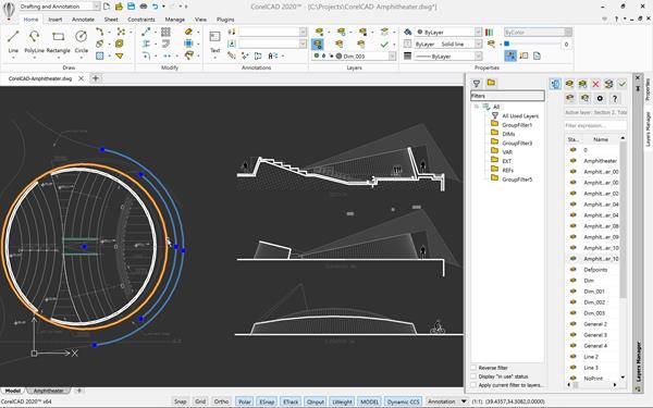
OTTAWA, ON, Canada, Feb 20, 2020 – CorelCAD 2020 is the professional and affordable CAD solution that streamlines 2D drawing, 3D modeling, and 3D printing processes. New Lasso Selection and Layer group filters enable users to work more efficiently; while enhanced MultiLeader and Dimension tools, Custom Blocks, and 3D capabilities offer even greater control. Available for Windows and macOS, CorelCAD 2020 enhances efficiency across a full spectrum of design, architecture, and engineering projects.

CorelCAD 2020


“CorelCAD 2020 offers users a complete CAD application that’s more powerful and intuitive, enabling them to achieve exceptional results faster,” said Klaus Vossen, Senior Product Manager, CorelDRAW. “This smart and affordable solution increases productivity and boosts performance across the entire 2D and 3D technical design workflow.”

Work faster with new Layer group filters and enhanced Custom Blocks

Even when working with complex files that may have hundreds of layers, new Layer group filters enable users to group referenced layers together to gain quick and easy access to specific areas of a drawing. Improvements to Custom Blocks include a new Save option for easy sharing, plus a new Test mode to evaluate block behavior, ensuring specifications are met without having to exit the block editor.


CorelCAD 2020 Layer Group Filters Windows


Experience a more intuitive 2D drafting workflow

The new Lasso Selection Tool and enhanced drawing constraint features enable users to precisely specify the object to be selected and how dimensional constraints are displayed. The new Pattern option offers improvements to the Copy tool, making it simple to duplicate objects along a path in a variety of shapes and create a specified number of copies in a linear pattern. User-favorite tools, including hatch, dimension, and rotate are fine-tuned to be more intuitive.

Do more with advancements to 3D modeling commands

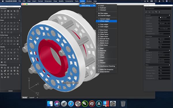
The enhanced Sweep tool provides a new Bank option to design advanced 3D shapes that rotate along the specified sweep path. New ‘Offset edges’ and ‘Convert edges’ commands allow users to easily create 2D wireframe objects from the edges of 3D solids or surfaces.


CorelCAD 2020 3D Modeling Offset Convert Edges macOS


Maximize productivity with enhanced PDF output

Ensure CAD designs can be viewed with full detail by creating layers in PDF files that reflect the layers in the original DWG file. Project efficiency is improved with the ability to batch print multiple drawing files into a single PDF.

Save time with the New Data Extraction Wizard (Windows version)

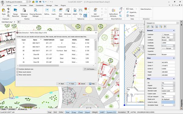
CorelCAD 2020 users on Windows can now specify and extract a set of object and/or block attributes which can be displayed in a table on the drawing or saved in an external file for easy sharing. The Wizard enables users to extract data directly from the technical drawing, producing a table-type sheet to automate the creation of BOMs, parts catalogs, order lists, and more.


CorelCAD 2020 Data Extraction Wizard Windows


Pricing and Availability

CorelCAD 2020 is available in English, German, Spanish, French, Brazilian Portuguese, Italian, Czech, Polish, Russian, Turkish, Simplified Chinese, Traditional Chinese, Japanese, and Korean. Pricing is US$699 / €829.99 / £799.99 for the full version and US$199 / €239.99 / £232.99 for the upgrade. Education and volume licenses are also available.

*GBP and EUR prices include VAT.

About CorelCAD

CorelCAD is an affordable and powerful CAD software solution for precise 2D drafting and 3D design. With industry-standard CAD features and advanced DWG support, it is a true CAD solution for architectural and mechanical needs. For more information, please visit www.coreldraw.com/corelcad.

About Corel

Corel products enable millions of connected knowledge workers around the world to do great work faster. Offering some of the industry’s best-known software brands, we give individuals and teams the power to create, collaborate, and deliver impressive results. Our success is driven by an unwavering commitment to deliver a broad portfolio of innovative applications – including CorelDRAW, ClearSlide, MindManager, Parallels, and WinZip – to inspire users and help them achieve their goals. To learn more about Corel, please visit www.corel.com

Leica Introduces Nova TS60 Total Station

0

HEERBRUGG, Switzerland, Feb 20, 2020 – Leica Geosystems, part of Hexagon, announced today the new Leica Nova TS60, the world’s most accurate total station, with newly integrated DynamicLock and AutoHeight features.


Leica Nova TS60Leica Nova TS60 total station


The new version of the TS60 total station is now equipped with DynamicLock, allowing the instrument to lock onto a moving prism, and devised with AutoHeight, enabling users to get the instrument’s height with a simple button press. With these new integrated capabilities and sub-second and sub-millimeter accuracy, the TS60 is the most accurate total station for minimizing risks of downtime and unexpected costs and delays.

“We use the TS60 primarily when measuring large surveying networks for monitoring dams. Usually, we measure 20-35 points from a station, by conducting at least three sets of measurements in two phases; therefore, we observe each point a minimum of six times. With the new TS60 we achieve highly accurate results and save a lot of time as it is much quicker in navigating to the points than with previously-used instruments,” said Thorsten Zimmer, senior surveyor at Axpo Power AG. “Another good feature of the TS60 is that one can take a picture of the surrounding area with the instrument, including the previously observed points on that picture as an icon. We find this to be a good method of documenting newly observed points.”

The world’s most accurate total station

The TS60 is the only total station in the market that enables users to work with an angular accuracy of 0.5” and a distance accuracy of 0.6mm + 1ppm. Designed and manufactured to the highest levels of quality, this high-end total station is the best fit for most demanding projects due to its reliability even in the harshest conditions.

TS60 users can easily manage, process, analyse and quality check data with the intuitive Leica Captivate onboard software and processes the information back in the office with Leica Infinity survey software. The easy-to-use touch technology and user-friendly apps in the TS60 enable users to perform a variety of surveying tasks.

“We designed the TS60 for highly demanding surveying projects, requiring the world’s highest levels of accuracy and to reliably operate even in the harshest conditions. We integrated new capabilities to help surveyors save time and increase productivity with the fastest re-lock in case of interrupted line of sight – be it rain, fog, dust, sun, heat shimmer or reflections – and automatically measure instrument height,” said Hans-Martin Zogg, business director at Leica Geosystems.

To learn more about the new Leica Nova TS60, please visit: leica-geosystems.com/TS60

About Leica Geosystems

Revolutionizing the world of measurement and survey for 200 years, Leica Geosystems, part of Hexagon, creates complete solutions for professionals across the planet. Known for premium products and innovative solution development, professionals in a diverse mix of industries, such as aerospace and defence, safety and security, construction, and manufacturing, trust Leica Geosystems for all their geospatial needs. With precise and accurate instruments, sophisticated software, and trusted services, Leica Geosystems delivers value every day to those shaping the future of our world.

Hexagon is a global leader in sensor, software and autonomous solutions. We are putting data to work to boost efficiency, productivity, and quality across industrial, manufacturing, infrastructure, safety, and mobility applications.

Our technologies are shaping urban and production ecosystems to become increasingly connected and autonomous — ensuring a scalable, sustainable future.

Hexagon (Nasdaq Stockholm: HEXA B) has approximately 21,000 employees in 50 countries and net sales of approximately 3.9bn EUR. Learn more at hexagon.com and follow us @HexagonAB.

Carlson Appoints Pawel Grabowski as Regional Sales Director for Eastern Europe

0

MAYSVILLE, KY, USA, Feb 20, 2020 – Carlson Software continues to expand its representation in Europe, naming Pawel Grabowski of Warsaw, Poland, as the company’s Regional Sales Director for its land development product line in Eastern Europe.


Pawel Grabowski


The countries Grabowski will be covering include his homeland of Poland, plus the Baltic countries of Estonia, Latvia, and Lithuania; Belarus, Ukraine, Slovakia, Romania, and Moldova. “I look forward to conducting sales and training seminars for both dealers and customers, as well as visiting Carlson’s existing dealers and customers to better meet their needs. I will also be attending regional conferences,” he says.

Grabowski has worked as a land surveyor both during his education in Geodesy and Cartography at the Military University of Technology in Warsaw and following it. He has also worked as a sales manager for a dealer of surveying equipment in Poland, responsible for the sales of GNSS receivers, total stations, and 3D laser measurement devices.

“Carlson Software is very popular in Eastern Europe through its data collection software options, SurvCE and SurvPC, but many regional surveyors are not aware that Carlson also produces good quality hardware and office software,” notes Grabowski. “My aim is to educate people that Carlson has the full solution – that it can efficiently take them from field to finish.”

In addition to attending the Western Geodetic Society’s Geoforum 2020 in Lviv, Ukraine, to be held April 1 to 3, Grabowski and members of the Carlson EMEA team are organizing a dealer meeting to be held in Cracow, Poland, on June 11 and 12.

The Carlson Software land development product line includes both hardware and software for the agricultural, aerial mapping, civil engineering, construction, data collection, GIS, and land surveying industries. Carlson also provides comprehensive solutions for machine control and mining.

Grabowski can be reached via email at pgrabowski@carlsonsw.com or by phone at +48 888 888 038 or by Skype at p.grabowski23. For more information about the complete line of Carlson Software, visit www.carlsonsw.com

Trimble Announces Call for Speakers for 2020 Dimensions User Conference

0

SUNNYVALE, CA, USA, Feb 20, 2020 – Trimble (NASDAQ: TRMB) has opened its Call for Speakers for the 2020 Trimble Dimensions User Conference, which will be held November 2-4 at Gaylord Opryland Resort and Convention Center in Nashville, Tennessee. Emphasizing education, innovation and networking, this biennial event is a premier opportunity for speakers to share insights and real-world experiences.

Of particular interest to the thousands of attendees at Dimensions are sessions to learn about and experience groundbreaking technology trends in construction, geospatial surveying and mapping, autonomy, civil engineering, architecture and design, agriculture, transportation, utilities and more.

Those interested in presenting at an educational session can learn more at dimensions.trimble.com/sessions/call-for-speakers, and may submit speaker proposals through April 8, 2020. Notifications of acceptance will be made in early June, and speakers will receive a significantly discounted full-conference registration rate.

Additional information about Trimble Dimensions, including registration details, will be available in the coming weeks.

About Trimble Dimensions International User Conference

Trimble Dimensions User Conference showcases how technology is transforming the way professionals work to achieve success. During three days, attendees have ongoing opportunities for sharing knowledge, networking with industry leaders, building relationships, developing new contacts, and discovering how to overcome challenges in today’s competitive business environment. Highlights include more than 500 educational sessions, many offering professional development hour (PDH) credits; hands-on software training; keynote and executive-level presentations; an on-site innovation Expo; and opportunities to see Trimble solutions at work.

For more information, visit dimensions.trimble.com or email trimble_dimensions@trimble.com.

About Trimble 

Trimble is transforming the way the world works by delivering products and services that connect the physical and digital worlds. Core technologies in positioning, modeling, connectivity and data analytics enable customers to improve productivity, quality, safety and sustainability. From purpose-built products to enterprise lifecycle solutions, Trimble software, hardware and services are transforming industries such as agriculture, construction, geospatial and transportation. For more information about Trimble (NASDAQ: TRMB), visit: www.trimble.com.

Graitec Gets Autodesk CAM Certification

0

PARIS, France, Feb 20, 2020 – GRAITEC, an international Autodesk reseller for AEC and Manufacturing and an Autodesk® Platinum Partner across Europe, is delighted to announce the achievement of CAM Certification for Autodesk’s Advanced Manufacturing solutions.

As manufacturing companies push the boundaries of both design and production workflows, Autodesk’s Advance Manufacturing solutions enable them to make anything and overcome challenges that they may not currently have a solution for using existing CAM and CNC machinery.

Steve Houlder, GRAITEC COO comments: The CAM certification represents an excellent achievement by our manufacturing team and further enhances our global Create & Fabricate strategy whilst giving us the capability to help our Autodesk manufacturing clients enhance their production workflows and take advantage of advanced manufacturing solutions to deliver innovation both now and in the future.

Nick Johns, Head of Digital Manufacturing UK said; “We are delighted to have become certified as an Autodesk CAM Specialised Partner. Having a robust digital manufacturing strategy is critical in order to transform the ways our manufacturing customers design, make and sell products, to help them make better, more innovative products, to sell more, and generate greater profits through the future of making.

Graitec are one of the largest Autodesk platinum partners in the world so this accreditation will allow us to support our clients even further on their journey to digital manufacturing excellence and position Graitec as the partner of choice for manufacturing organisations in the UK”

Jas Pawar, UK Sales Manager for Advanced Digital Manufacturing explains: The CAM certification will allow Graitec to support the Manufacturing industry to do More with Less and achieve the impossible with premium CAM software solutions; PowerMill, FeatureCAM, PowerShape & PowerInspect. Our customers will be in prime position to take advantage by Making, Fabricating, Printing and Inspecting their parts faster than ever!

Autodesk Advanced Manufacturing solutions meet the needs of a huge variety of manufacturers ranging from those who are still using manual programming methods and need to expand, existing manufacturing companies that have previously invested in CAM software they have started to outgrow, through to companies whose investment in CNC machinery stretches to millions and have the need to maximise machine potential in order to speed up investment returns.

About GRAITEC

Founded in 1986, GRAITEC is an international Autodesk Partner across Europe, North America and Russia including an Autodesk Developer Partner, delivering high-performance Manufacturing, Simulation, Fabrication and Data Management solutions and consultancy through their Create, Simulate, Fabricate and Manage global strategy. Operating throughout 50 offices across 11 countries worldwide, GRAITEC goals is to offer productivity, efficiency and performance solutions and consulting to its customers in both the AEC and Manufacturing arena’s. With 550 employees, GRAITEC is an innovation focused company whose products are used by more than 100,000 professionals worldwide. For more information, please visit www.graitec.com.

ANSYS Appoints Robert Calderoni, Ravi Vijayaraghavan to its Board

0

PITTSBURGH, PA, USA, Feb 20, 2020 – ANSYS (NASDAQ: ANSS) announced that Robert Calderoni and Ravi Vijayaraghavan have accepted appointments to the ANSYS, Inc. Board of Directors effective March 1, 2020 – bringing with them decades of executive strategy and technological innovation, as well as business and financial experience.

Robert Calderoni has more than three decades of executive experience leading large, multinational software, technology and service companies. He currently serves as the chairman of Citrix Systems, Inc., a multinational software company that provides applications, software as a service and cloud computing technologies. Prior to his current role, he was the executive chairman of Citrix and served as its interim chief executive officer and president. Previously, he was the chairman and chief executive officer of Ariba, Inc., a cloud applications and business network company until it was acquired by SAP AG and served as a member of the global managing board and president of SAP Cloud at SAP. Prior to joining Ariba, he held senior finance roles at Apple and IBM and served as chief financial officer of Avery Dennison Corporation, a publicly traded industrial materials company.

Ravi Vijayaraghavan is a senior partner at Bain & Company, Inc., a management consulting firm, and director and head of its Asia-Pacific technology practice, as well as a member of its global partner promotion and compensation committee. Over his 25-year career, Ravi has played an integral leadership role in establishing and expanding Bain’s technology and telecommunication practice across the Asia-Pacific region. He is a senior member of Bain’s mergers & acquisitions, private equity and telecommunications, media and technology practices. His experience spans a broad range of technology markets, including software, hardware, semiconductors, and services, as well as mobile and fixed telecommunications operations across geographies in North America, Europe and Asia. He is a member of the board of overseers for WGBH, a Boston-based public broadcaster, and previously served as a member of the board of the Singapore Land Authority.

“We are proud to have Bob Calderoni and Ravi Vijayaraghavan join the Ansys board,” said Ronald W. Hovsepian, Ansys chairman of the board. “Bob has a deep knowledge of engineering technology challenges, a strategic vision and a proven track record of success in bringing innovative digital solutions to market. Ravi brings extensive experience and expertise in business transformation and the global operational management of high-tech companies.”

“Both Bob and Ravi are accomplished leaders with tremendous experience in business management, innovation and finance,” said Ajei Gopal, president and CEO of Ansys. “Their expertise will complement our strategy of pervasive engineering simulation and strengthen our ability to help customers achieve digital transformation.”

About ANSYS, Inc.

If you’ve ever seen a rocket launch, flown on an airplane, driven a car, used a computer, touched a mobile device, crossed a bridge or put on wearable technology, chances are you’ve used a product where ANSYS software played a critical role in its creation. ANSYS is the global leader in engineering simulation. Through our strategy of Pervasive Engineering Simulation, we help the world’s most innovative companies deliver radically better products to their customers. By offering the best and broadest portfolio of engineering simulation software, we help them solve the most complex design challenges and create products limited only by imagination. Founded in 1970, ANSYS is headquartered south of Pittsburgh, Pennsylvania, U.S.A., Visit www.ansys.com for more information.