
Using Bentley Open Applications for Roadway and Utility Works Accelerated the Project Schedule by 10% and Saved INR 10 Million in Costs
Project Summary | Organization: Larsen & Toubro | Solution: Roads and Highways | Location: Ahmedabad, Gujarat, India


Modernizing Infrastructure for Smart City Initiative
Located 100 kilometers southwest of Ahmedabad, India, Dholera Special Investment Region is being built close to the trading centers of Gujarat and will be easily accessible from the Delhi-Mumbai Industrial Corridor, making it a potential global trading and manufacturing hub, supporting economic development and quality of life for city residents and workers. Encompassing 920 square kilometers, the project is India’s first greenfield smart city development, boasting smart infrastructure, utilities, connectivity, and technology. The region will have four-way connectivity via an express highway, a metro, a dedicated international airport, and a nearby port. It will be powered by electricity generated from renewable energy through a dedicated five-gigawatt solar park.
Larsen & Toubro is responsible for utility works spread over a 57-square-kilometer area and delivery of 174.25 kilometers of highway network to provide efficient, intelligent, and sustainable services and transportation. The project required designing modern infrastructure to support intelligent city development, including modeling and analyzing varying roadway alignments with utility services passing through various parts of the corridor. “Services and utilities running within the roadway reserves include portable water, sewer, industrial effluent, and recycle water networks, as well as power duct, ICT duct, SCADA, and street lighting,” said Rajesh Kumar of L&T, head of digital at Larsen & Toubro. As a massive smart city initiative, the client mandated BIM implementation throughout design, construction, and lifecycle maintenance and management.
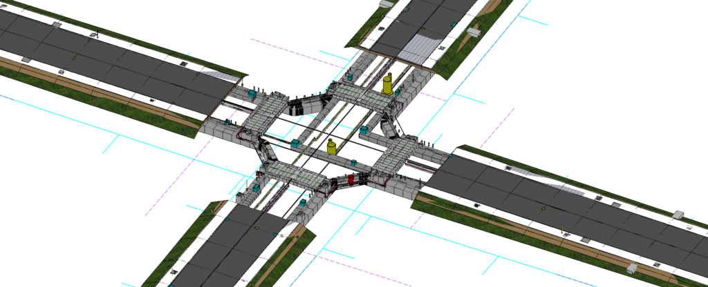
The Dholera Smart City project incorporates intelligent urban management, promoting economic development and environmental and social sustainability. Image courtesy of Larsen & Toubro.
Coordinating and Integrating Data and Stakeholders
To meet the deliverables and BIM requirements, Larsen & Toubro needed to ensure seamless integration of power and water utilities with the roadway works. The team used CAD software applications during the initial project stages; however, the software failed to accommodate the voluminous data and presented data exchange issues. “At the beginning stage, we decided to go with Autodesk software like Revit for modeling utilities [that stretched] 72 kilometers long, and faced some issues with data transfer from the design model; [also,] handling the model with such a large number of the details is very difficult in that software,” said Kumar. As a BIM-mandated project, the 3D model should carry its design data attribute over to the project BIM model to be used later during operations and maintenance. With seven different individual models having varying alignments and levels along the road length, as well as data from various services and utilities, Larsen & Toubro needed a digital application to combine those models and data into a unified 3D BIM model.
Compounding the data coordination and integration issues, multiple disciplines and stakeholders, including architects, engineers, contractors, and government agencies, also needed to be coordinated to reduce design and construction conflicts. “We have faced issues at the junction locations where we will be getting multiple clashes among the utility services passing through. [These clashes] will be a very big issue at site-level execution,” said Dr. Kumar. To streamline workflows, avoid clashes, and optimize execution, Larsen & Toubro realized that they needed a connected digital solution capable of integrating the entire project team, utility works, and roadway alignments, as well as of performing clash detection among the different design components.
Leveraging Open 3D Modeling Technology
Larsen & Toubro conducted design and analysis of the utilities using Bentley’s OpenFlows applications and used OpenRoads for modeling the various roadway alignments. Based on the subsurface utility design and analysis workflow, Larsen & Toubro exported the hydraulic design models into OpenRoads along with all the design attributes, integrating them with the roadway models to create the project BIM model. The solution provided a centralized digital environment that enabled Larsen & Toubro to simulate different scenarios, analyzing factors ranging from energy efficiency to environmental impact, ensuring sustainable, efficient designs.
Working in a collaborative BIM platform streamlined workflows and facilitated clash detection. “Bentley has helped with their clash detection feature and helped to resolve those clashes in the design stage itself, which has given a clear idea for the project team regarding the execution,” said Dr. Kumar. Leveraging Bentley Open applications supported not only collaborative processes and data integration throughout the design stage, but also the entire lifecycle of the project through construction, maintenance, and management, meeting the client-mandated BIM requirements.
Driving Savings, Sustainability, and Lifecycle Management
Working in an open, centralized digital environment enhanced planning and design, automated previous manual modeling processes, and facilitated stakeholder collaboration and clash detection. It has also provided a digital representation of the assets that can be used for better city management and maintenance. “By using the subsurface utility design and analysis workflow [in OpenRoads], we have avoided manual modeling processes and saved many resource hours of modeling,” said Kumar. “With Bentley’s clash detection capability, we have resolved the clashes at the very beginning stage of the design and thereby helped the project site team [with] clear execution.” The connected digital solution streamlined design and construction, mitigating risks, saving 1,000 work hours, and reducing costs by INR 10 million. Using Bentley’s BIM applications, Larsen & Toubro improved productivity by 25%, accelerating the project schedule by 10%.
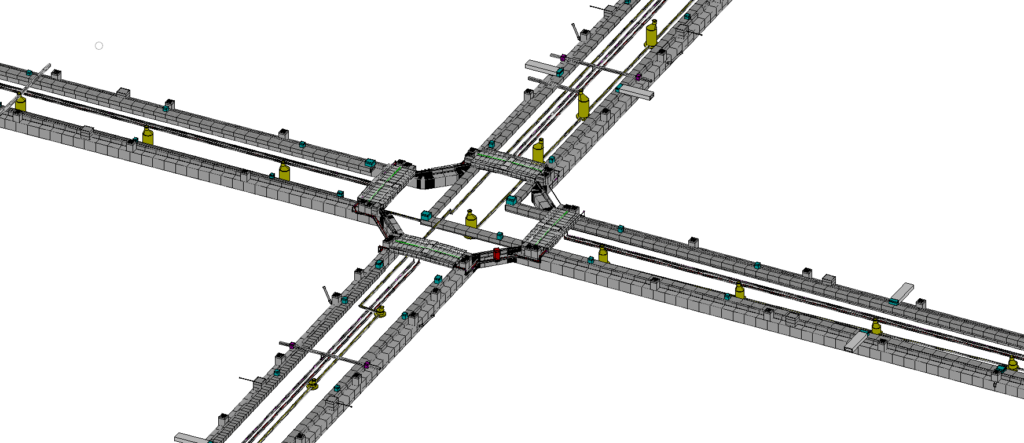
Larsen & Toubro improved productivity by 25%, accelerating the project schedule by 10%. Image courtesy of Larsen & Toubro.
Integrating BIM with the Internet of Things and other digital systems will enable real-time data collection and insight into the city’s infrastructure performance, facilitating intelligent transport systems that support smart city development, as well as environmental and social sustainability. The Dholera project emphasizes development of green spaces, incorporates renewable energy sources, and modernizes infrastructure, including roadway networks, utilities, and healthcare facilities. It will foster an eco-friendly culture, connectivity, and sustainable living. “The integration of smart technologies—such as efficient waste management systems, smart grids, and intelligent transportation systems—can enhance the livability of the city by improving convenience [and] safety while reducing resource consumption,” said Dr. Kumar.

Project Objectives:
- To provide roadway and utility design works supporting development of Dholera Smart City.
- To establish a connected digital platform to facilitate data integration and meet BIM requirements.
Project Playbook: LumenRT, OpenFlows, OpenRoads
Fast Facts
· The Dholera Smart City project incorporates intelligent urban management, promoting economic development and environmental and social sustainability.
· Larsen & Toubro is responsible for roadway and utility works, providing smart and efficient connectivity and energy use.
· Larsen & Toubro relied on Bentley Open applications to meet lifecycle BIM requirements, optimizing design and project execution.
ROI
· Working in a connected digital environment saved INR 10 million in costs.
· Using OpenRoads’ subsurface utility design analysis workflow automated previous manual modeling processes, reducing work hours from 4,000 to 3,000.
· Larsen & Toubro improved productivity by 25%, accelerating the project schedule by 10%.
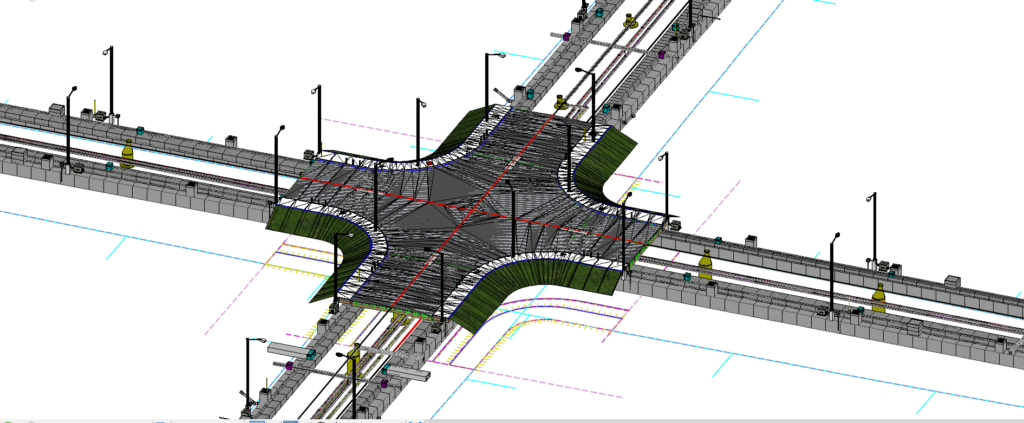
Using OpenRoads’ subsurface utility design analysis workflow automated previous manual modeling processes, reducing work hours from 4,000 to 3,000. Image courtesy of Larsen & Toubro.


Author: Oana Crisan, Product Marketing Manager, Bentley Systems.
Oana Crisan is a product marketing manager focused on civil design engineering solutions and applications at Bentley Systems. She is responsible for the development of go-to market strategies, creating consistent messaging and content, and enabling sales to achieve new business growth. She holds a BA in business information systems from Dublin Business School, Ireland, and a BA in international relations and European studies from Petru Maior University, Târgu Mureș, Romania. She can be reached at oana.crisan@bentley.com.
")